TERRESTRIAL HYDROLOGY LAB
at University of Cincinnati

DATA FROM OUR LAB
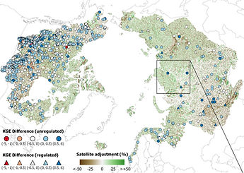
RADR
RADR (Remotely-sensed Arctic Discharge Reanalysis): a daily discharge product for 486,493 pan-Arctic river reaches from 1984-2018 that assimilates 9.18 million river discharge estimates made from 155,710 satellite images into hydrologic model simulations.
Download: RADR
Reference: Feng, D., Gleason, C.J., Lin, P. et al. Recent changes to Arctic river discharge. Nature Communications 12, 6917 (2021). [Link]
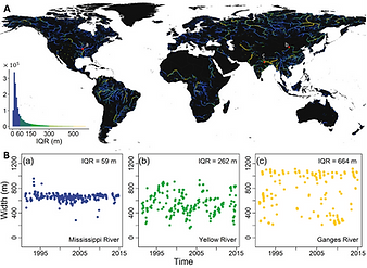
GLOW
GLOW (Global LOng-term river Width): a 37-year global river width dataset derived from Landsat satellites for all global rivers wider than 90 m for 1984-2020.
Download: GLOW
Reference: Feng, D., Gleason C.J., Yang X., Allen G.H., and Pavelsky T.M., 2022, How have global river widths changed over time? Water Resources Research, DOI: 10.1029/2021WR031712 [Link]